
AI + BeiDou: High-Precision Positioning Moves Beyond Navigation
The shift around BeiDou is not only better accuracy, but a change in the role of the terminal: from a navigation device that used to “tell a person where they are,” it is moving toward a spatial-intelligence node that senses position, supports judgment and underpins autonomous operation. Centimeter-level positioning, RTK, PPP-RTK and short-message capability are moving down into baseband chips, receiver boards and vehicle, airborne and handheld terminals, making positioning a baseline capability of terminal hardware.
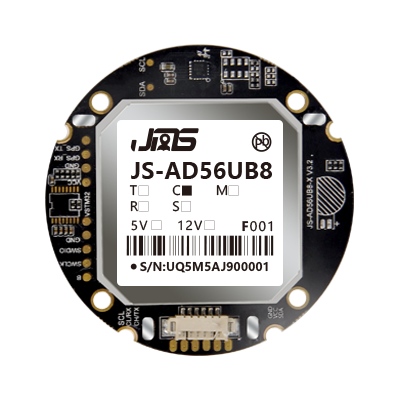
Positioning is a system-level chain
What drives this change is that downstream scenarios demand higher accuracy, stronger anti-interference and continuous reporting. Lane-level navigation, drone operations, vehicle tracking, handheld and wearable devices, and aviation terminals no longer settle for coarse meter-level positioning; they often need stable convergence in urban canyons, obstructed environments and high-speed motion. Positioning is a systems engineering effort rather than a stack of single-device specs. The chip determines sensitivity and solving capability, the board handles differential solving and interface adaptation, the antenna affects signal reception quality, the terminal structure and power supply determine stability in real use, and the back-end differential platform pushes down corrections.
Obstructed environments are the real difficulty
In real environments, the positioning difficulty often lies not in open-sky scenarios but in signal reflection and multipath under urban canyons, building obstruction and tree cover. There, satellite signals are easily blocked or refracted, and the receiver must keep tracking under weak signal and return to a fixed solution quickly; the board's solving algorithm, the antenna's anti-multipath design and the timeliness of back-end corrections together determine the final result. For industry terminals, whether positioning stays continuous and whether it reconverges quickly after a lock loss often affects operational reliability more than nominal static accuracy. Running convergence and fix-rate validation in real scenarios early on is more informative than relying only on the accuracy figures on a datasheet.
Layer selection by scenario
The combination of positioning and AI further raises the bar for the data link. Position, trajectory and environment information solved on the terminal must work together with upper-layer algorithms and business rules to form a decision; the continuity, latency and coordinate consistency of positioning data directly affect the reliability of downstream judgment. This is why industry terminals increasingly prefer suppliers that cover the full chain from chips and boards to antennas and finished devices, reducing the interface and calibration cost of cross-vendor integration. The listed GNSS modules and high-precision antennas, RTK high-precision positioning boards and BeiDou terminals and RTK base stations, together with Jierui Tongchuang (MXGNSS distributor) and positioning solution vendor JUMPSTAR, can be checked separately for vehicle, handheld, wearable and base-station needs.
| Scenario | Core needs | What to check |
|---|---|---|
| Consumer navigation | Cost-sensitive, everyday route guidance | Basic positioning stability, power draw |
| Industry terminals | Continuous positioning, environmental resilience | Reconvergence after lock loss, protection grade, interfaces |
| High-precision scenarios | Centimeter level, stable fixed solution | RTK convergence speed, fix rate, anti-multipath |
Selection can be layered by accuracy grade, communication method, battery life and form factor. Requirements for antenna gain, board interfaces and terminal protection grade differ widely across scenarios, and clarifying the operating environment, obstruction and reporting frequency early is more efficient than revising boards repeatedly afterward.
Comments
No comments yet. Be the first to comment.